A saucer shape wetland situated between N 29 32’ to 29 50’ and E 78 to 78 15’. It is located between the Haridwar- Najibabad Highway NH 74 and the natural course of Ganga to the south of it in Haridwar Forest Division, Uttarakhand.
Source of water :: Wetland is connected many small old channels to River Ganga and it is surrounded by Chiriyapur Range on east and Western side Shyampur range on the northern side Rajaji Tiger Reserve and southern side covered by Lakshar range.
Before the enforcement of Wildlife (Protection) Act of 1972, limited wildlife shooting was permitted here. The working plans in the initial 70–80 years of the management history (1896–1973) aimed only at obtaining more revenue out of the forest wealth. Later 1973 onward from there was a shift with the inclusion of wildlife conservation initiatives in the working plans.
On August 14, 2005, declared the area as a Conservation Reserve by the Honourable President of India Prof. A.P.J. Kalam .
AREA
37.83 km2 of Reserve Forest
ALTITUDE
200 to 250 meters above MSL
TEMPERATURE
20 in January, 440 in May month
CLIMATE
The area experiences subtropical climate. Annual rainfall averages about 1300 mm (recorded between 1997 and 2007) and is most prominent during June–September (monsoon).
FAUNA
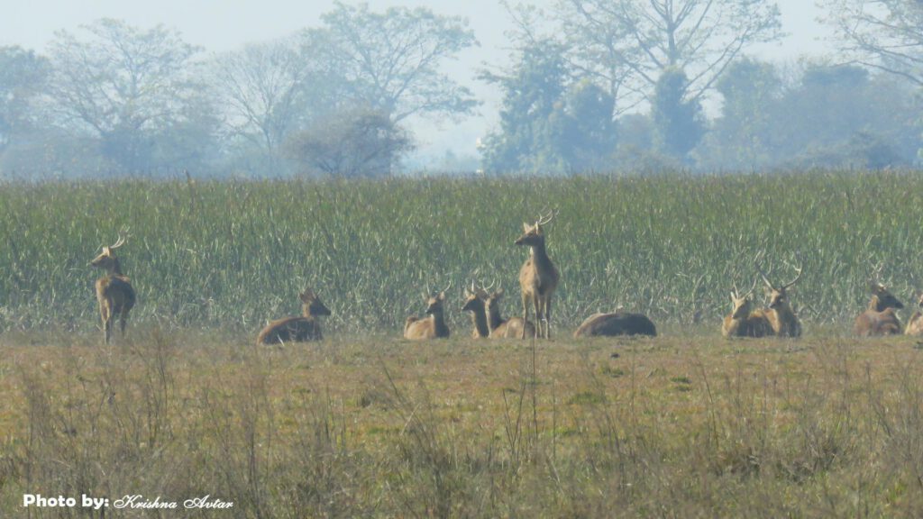
Swamp Deer, Spotted deer, elephant, blue bull, wild boar, monkey, langur, mongoose, hare, common leopard and occasionally tiger, jungle cat, otter, porcupine, sambar, barking deer, and hog deer that are also seen in the area.
The spectacular terai landscape of the study area is a mosaic of short and tall grasslands, tropical mixed moist deciduous forests, and secondary scrub. Throughout the landscape, shifting of river channels over time has left behind many old channels where numerous seasonal and perennial swamps (“tals”) or wetlands occur.
The central swamp zone represents one of the above swamps such-oxbow-lake formed along the eastern bank of River Ganges. Surrounding areas get submerged during the monsoon. A number of small rivulets (total 30-32 in number) emerge from the woodland and discharge into Jhilmil Jheel, which finally drain into the Ganges. Most of them provide water throughout the year, while some dry up for about 6-7 months. The reserve area also receives water from the Shivaliks formations of Chidiyapur and the adjacent ranges such as underground streams, locally called “Choyas.”